Where the Water Used to Be: The Changing Shore Beneath Fort Perch Rock
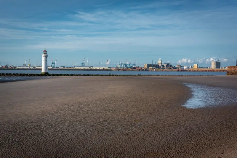
Stand on the promenade at New Brighton and look out towards Fort Perch Rock, and the scene feels fixed enough. A squat, sandstone fort. A lighthouse. A wide sweep of sand when the tide is out. But the shore beneath that view has been edited and re-edited for nearly two centuries, by nature and by people who thought they could improve on nature. The fort did not simply arrive on a stable patch of the Wirral coast; it was planted on a rock in a busy, shifting estuary, and the coastline around it has been on the move ever since.
A Fort Built for a Coast That Kept Moving
Fort Perch Rock was built in the 1820s to guard the approaches to Liverpool, and its name gives away the original geography. Perch Rock was a sandstone outcrop surrounded by water at high tide, with sand and mud exposed as the Mersey emptied. The fort was designed for that world: a low, compact defensive structure that could fire across the Rock Channel and the estuary beyond. It was never meant to sit in a landscaped park with a car park nearby. It was meant to sit in water, or at least in the tidal zone where water, sand and navigation mixed.
That distinction matters when you try to read the modern shoreline. Today the fort is reached by a causeway and a stretch of promenade, and at low tide it can feel almost landlocked by sand. In the early nineteenth century, the relationship between fort, rock and channel was much more fluid. The Rock Channel was a working navigation route, and the sandbanks around it were hazards to be watched, not scenery to be enjoyed. The fort’s position made sense because the coastline was active — and that activity has never really stopped.
Reading the Old Maps
One of the most rewarding ways to understand the change is to compare historic maps of the New Brighton shore. Ordnance Survey sheets from different decades, tithe maps, and Victorian town plans all show a coastline that refuses to match neatly. The promenade was extended, sea walls were built, landing stages came and went, and the Marine Lake was carved out as a leisure attraction. Each intervention changed how water moved across the sand.
Old photographs are just as revealing. They show the fort with different proportions of sand and water around it, and they show crowds behaving as if the shore were a stage. New Brighton Pier, opened in the 1860s and demolished in the 1970s, once pushed out into the Mersey near the fort’s patch of coast. Its piles and landing stages would have influenced local currents and sediment, even if no one was thinking about coastal processes in quite those terms. The pier is gone, but its absence is part of the story too. Coastlines remember what we remove as well as what we add.
What the Tide Still Shows
At low tide, the shore around Fort Perch Rock becomes a kind of open-air archive. You do not need specialist equipment to notice the marks of change. Look for the lines of old slipways, patches of harder ground, and the way sand gathers against the causeway. Look at the difference between the smooth, recently worked sand and the rougher areas where stones and broken shell collect. These are small clues, but they point to a bigger truth: the surface is always being rearranged.
The Rock Channel itself is a good place to start. Its depth and alignment have mattered to shipping for centuries, and dredging and training works in the wider Mersey estuary have altered the movement of water and sediment. You do not have to understand the hydrography to see the result. Sandbanks grow, shrink and migrate. Channels shift. A route that looks obvious at one low tide may look different after a winter of storms. The fort, standing on its rock, is a fixed point in a landscape that is anything but fixed.
Defences, Dredging and the Shape of the Shore
Coastal defence works have also left their mark. Sea walls and promenades protect the town, but they change how waves arrive and where sand is deposited. Groynes interrupt the drift of sediment along the shore. The Marine Lake, opened in the late Victorian period, created a new edge between controlled water and tidal water. None of these features was designed with Fort Perch Rock as the centre of attention, yet together they have reshaped the setting that gives the fort much of its character.
There is a useful lesson here for anyone interested in heritage. A landmark is not just a building. It is a building plus its setting, and that setting can change as much as the building itself. The fort’s sandstone walls may be much the same as they were a century ago, but the ground around them has been rearranged by storms, dredging, defence and leisure. That is why old photographs can feel slightly disorienting. They show a fort we recognise in a shoreline we almost recognise.
A Future Written in Sediment
What does all this mean for the fort’s future? In 2026, the obvious pressures are familiar ones: flood risk, erosion, the cost of maintaining sea defences, and the wider question of how the Wirral coast adapts to a changing climate. Fort Perch Rock is not alone in facing these issues. Coastal heritage sites across the UK are having to think about managed change rather than simple preservation. The question is not only how to keep the fort standing, but how to keep the story of its shoreline legible.
That story is worth telling precisely because it is unsettled. The fort was built for a coast that was already moving. It has survived because people kept adapting the shore around it. A future plan that treats the coastline as a static backdrop would miss the point. A better approach would treat the shifting sand as part of the heritage itself — something to interpret, not just to hold back.
Being a Shoreline Detective
You do not need a degree in geomorphology to enjoy this. Next time you visit Fort Perch Rock, walk the promenade at different states of the tide and look for the joins. Compare the sand against the causeway with the sand further out. Notice where debris collects. Look at the old maps on your phone, then look up. The coastline will not match the map exactly, and that is the interesting part.
The fort has watched the Mersey for two hundred years, but it has not watched a still scene. It has watched a working estuary rearrange itself around a fixed rock. The sand beneath your feet is the record of that rearrangement — and it is still being written.